Xplorer Maps
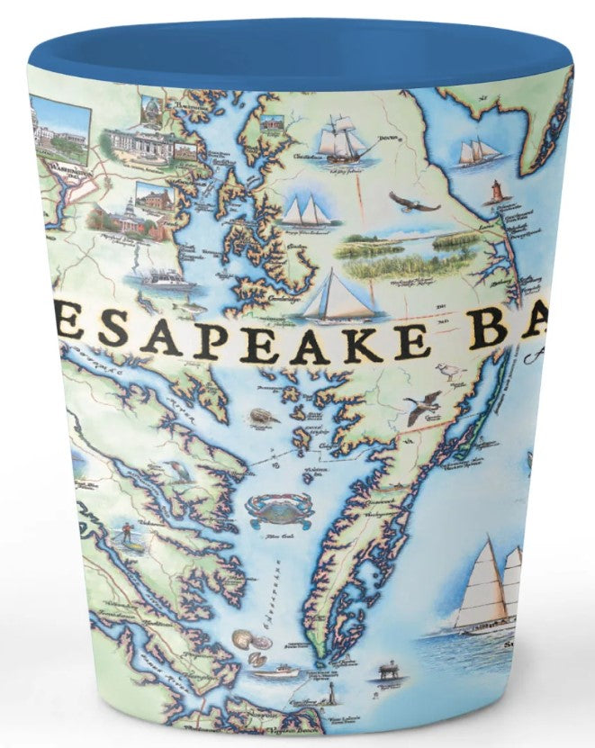
Ceramic Shot Glass - Chesapeake Bay Map
Ceramic Shot Glass - Chesapeake Bay Map
Couldn't load pickup availability
The Xplorer Maps Shot Glasses are designed around the exquisite map art by Xplorer Maps co-founder and illustrator Chris Robitaille. These ceramic, BPA-Free shot glasses are designed in the USA and printed with crystal clear graphics. These are perfect gifts for national park lovers, map connoisseurs and anyone who’s ever visited these incredible places.
- 1.5 oz. Capacity
- High Quality Ceramic Construction
- Superior, High-Quality Graphics
- BPA-Free
- 2.5" tall and 2.5" in diameter
- Hand-wash only
- Due to high quality graphics, dishwasher and microwave use is NOT recommended
Chesapeake Bay
Original, hand-drawn story map and accompanying gifts of Chesapeake Bay by renowned Illustrator and Xplorer Maps Co-Founder, Chris Robitaille.
The Chesapeake Bay is the largest estuary (where salt and freshwater mix) in the United States (and 3rd largest in the world!) with 150 rivers flowing into its drainage system; covering parts of six states (MD, VA, DE, PA, NY and WV). The word Chesepioc is an Algonquian word referring to a village “at a big river” and collectively, the Powtan tribes were the dominant group long before any Europeans arrived in the area.
Stretching more than 200 miles from the Susquehanna River in the north to Virginia Beach and the Atlantic Ocean in the south, the Chesapeake Bay watershed is “home” for more than 18 million people and is an integral part of the ecological and economic well-being of the region. The Bay is home to more than 3,600 species of animals and plants and provides important habitat for the wildlife as well as providing an abundance of recreational opportunities.
In addition to its famous Blue Crabs and sailing culture, the Bay is also renowned for dozens of shipwrecks and its role in The Civil War where the first ironclads battled near Hampton Roads, VA.
Stretching 191 miles long from Havre de Grace, Maryland to Virginia Beach, Virginia, the bay is the outlet to the Atlantic Ocean for many major rivers from north to south including: Susquehanna River, Patuxent River, Potomac River, Rappahannock River, York River, and James River. All of these rivers flow into the bay and run into the Delmarva Peninsula before flowing south and converging at the end of the peninsula at Cape Charles and Cape Henry and finally draining into the Atlantic ocean. From the northernmost point, to the southern end of the bay, the only access across the bay to the peninsula is by the famed Chesapeake Bay Bridge, which crosses the bay from Annapolis, across Kent Island, before arriving at Kent Narrows.
Showcased on the map are the major cities situated along the shoreline of the bay as well along the peninsula including: Baltimore, Annapolis, Washington D.C., Hampton, Portsmouth, Virginia Beach, and along the peninsula being Chesapeake City, Dover, and Cambridge. As a hub for history as the region of some of the first settlements for what would later become the United States of America, as well as a modern day center for government, education, arts and culture, this map showcases the features which give this area such a diverse reputation including: the U.S. Capitol Building in Washington D.C., Maryland State House in Annapolis, William Paca House, U.S. Naval Academy, St. John’s College, Washington College, Turkey Point Lighthouse, Fenwick Island Lighthouse, Assateague Lighthouse, Cape Charles Lighthouse, Cape Henry Lighthouse, and Chesapeake Light Tower.
Due to the size of the full drainage basin stretching across six states before opening up to the bay and the Atlantic Ocean, this region is the most fully encompassing example of a coastal region with endless harbors, beaches and smaller bays filling the map. While abundant with many smaller examples, some major water access points and well known landmark and historic sites showcased on the map include: Jamestown Harbor, Tall Ships at Norfolk, Tall Ships of Sultana, City Docks at Annapolis, Bugeye Edna of Lockwood, Skipjack Nathan of Dorchester, as well as the central east coast of the Delmarva Peninsula which is designated at the Assateague Island National Seashore.
While visitors to the bay can enjoy observing land fauna including: great blue herons, osprey, Canadian geese, and piping plovers, some of the major species that have brought visitors and fishermen to the region include: blue crab, horseshoe crab, a variety oysters and clams, as well as sand tiger sharks, sandbar sharks, bull sharks, Atlantic right whale, bottle-nose dolphin, and more.
Whether visiting the region for the history, architecture, culture, or endless outdoor recreation opportunities from kayaking, sailing, paddling, etc., adventure is available in all directions.
