Xplorer Maps
Hand-Drawn Map - Chesapeake Bay
Hand-Drawn Map - Chesapeake Bay
Couldn't load pickup availability
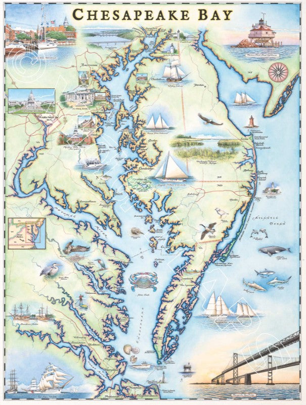
Original hand-drawn pen and ink/watercolor story map of Chesapeake Bay, the largest estuary in the United States, located in the Mid-Atlantic region of the east coast of the United States. This map highlights major cities, historical and landmark sites, and the flora and fauna quintessential to this coastal region.
Stretching 191 miles long from Havre de Grace, Maryland to Virginia Beach, Virginia, the bay is the outlet to the Atlantic Ocean for many major rivers from north to south including: Susquehanna River, Patuxent River, Potomac River, Rappahannock River, York River, and James River. All of these rivers flow into the bay and run into the Delmarva Peninsula before flowing south and converging at the end of the peninsula at Cape Charles and Cape Henry and finally draining into the Atlantic ocean. From the northernmost point, to the southern end of the bay, the only access across the bay to the peninsula is by the famed Chesapeake Bay Bridge, which crosses the bay from Annapolis, across Kent Island, before arriving at Kent Narrows.
Showcased on the map are the major cities situated along the shoreline of the bay as well along the peninsula including: Baltimore, Annapolis, Washington D.C., Hampton, Portsmouth, Virginia Beach, and along the peninsula being Chesapeake City, Dover, and Cambridge. As a hub for history as the region of some of the first settlements for what would later become the United States of America, as well as a modern day center for government, education, arts and culture, this map showcases the features which give this area such a diverse reputation including: the U.S. Capitol Building in Washington D.C., Maryland State House in Annapolis, William Paca House, U.S. Naval Academy, St. John’s College, Washington College, Turkey Point Lighthouse, Fenwick Island Lighthouse, Assateague Lighthouse, Cape Charles Lighthouse, Cape Henry Lighthouse, and Chesapeake Light Tower.
Due to the size of the full drainage basin stretching across six states before opening up to the bay and the Atlantic Ocean, this region is the most fully encompassing example of a coastal region with endless harbors, beaches and smaller bays filling the map. While abundant with many smaller examples, some major water access points and well known landmark and historic sites showcased on the map include: Jamestown Harbor, Tall Ships at Norfolk, Tall Ships of Sultana, City Docks at Annapolis, Bugeye Edna of Lockwood, Skipjack Nathan of Dorchester, as well as the central east coast of the Delmarva Peninsula which is designated at the Assateague Island National Seashore.
While visitors to the bay can enjoy observing land fauna including: great blue herons, osprey, Canadian geese, and piping plovers, some of the major species that have brought visitors and fishermen to the region include: blue crab, horseshoe crab, a variety oysters and clams, as well as sand tiger sharks, sandbar sharks, bull sharks, Atlantic right whale, bottle-nose dolphin, and more.
Whether visiting the region for the history, architecture, culture, or endless outdoor recreation opportunities from kayaking, sailing, paddling, etc., adventure is available in all directions.
The lithograph print by Chris Robitaille of Xplorer Maps is 18’’ wide and 24’’ tall.